Geolocate

The Green topographic map

Click on the map to display elevation.

About this map

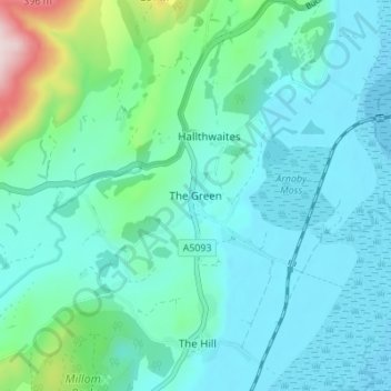
Name: The Green topographic map, elevation, terrain.

Location: The Green, Cumberland, England, LA18 5HL, United Kingdom (54.23204 -3.28198 54.27204 -3.24198)

Average elevation: 64 m

Minimum elevation: 0 m

Maximum elevation: 380 m

Other topographic maps

Click on a map to view its topography, its elevation and its terrain.

Arthuret

United Kingdom > England > Cumberland

Average elevation: 52 m

Emerald Pools

United Kingdom > England > Cumberland

Average elevation: 523 m

Penrith

United Kingdom > England > Cumberland

Average elevation: 162 m

Whitehaven

United Kingdom > England > Cumberland

Average elevation: 59 m

Gear up for your next adventure:

🧥Softshell Jacket - Windproof and breathable jacket for hiking
🛏️Sleeping Bag - Warm and compact sleeping bags for outdoor camping
🥾Trail Hiking Boots - Supportive boots for rough trails
🧶550 Survival Paracord - Versatile utility cord for emergency repairs and rigging
🧥Thermal Fleece Jacket - Versatile insulation for changing mountain temperatures

As an Amazon Associate, this site earns from qualifying purchases at no extra cost to you.