
Raqqa topographic map
Interactive map
Click on the map to display elevation.
About this map
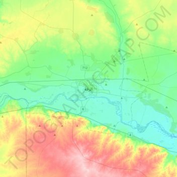
Name: Raqqa topographic map, elevation, terrain.
Location: Raqqa, ناحية الرقة, منطقة الرقة, Gouvernorat de Racca, Syrie (35.78968 38.84892 36.10968 39.16892)
Average elevation: 287 m
Minimum elevation: 229 m
Maximum elevation: 401 m
Other topographic maps
Click on a map to view its topography, its elevation and its terrain.
Muhafazat Dayr az Zawr
Muhafazat Dayr az Zawr, ناحية المنصورة, منطقة الثورة, Gouvernorat de Racca, Syrie
Average elevation: 421 m
Lac el-Assad
Lac el-Assad, منطقة الثورة, منطقة منبج, Gouvernorat de Racca, Syrie
Average elevation: 367 m
Tal Abu Serra
Syrie > Gouvernorat de Racca > Khirbat Nahit
Tal Abu Serra, Khirbat Nahit, ناحية عين عيسى, منطقة تل ابيض, Gouvernorat de Racca, Syrie
Average elevation: 389 m
Tell Abyad
Syrie > Gouvernorat de Racca > Tell Abyad
Tell Abyad, ناحية تل ابيض, منطقة تل ابيض, Gouvernorat de Racca, 022, Syrie
Average elevation: 354 m
Muhafazat ar Raqqah
Syrie > Gouvernorat de Racca > Raqqa
Muhafazat ar Raqqah, Raqqa, ناحية الرقة, منطقة الرقة, Gouvernorat de Racca, Syrie
Average elevation: 403 m