
Make a donation
Gear up for your next adventure:
As an Amazon Associate, this site earns from qualifying purchases at no extra cost to you.
Les Veyers topographic map
Click on the map to display elevation.
Make a donation
Gear up for your next adventure:
As an Amazon Associate, this site earns from qualifying purchases at no extra cost to you.
About this map
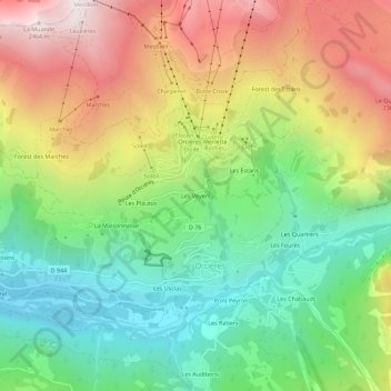
Name: Les Veyers topographic map, elevation, terrain.
Average elevation: 1,766 m
Minimum elevation: 1,254 m
Maximum elevation: 2,476 m
Make a donation
Gear up for your next adventure:
As an Amazon Associate, this site earns from qualifying purchases at no extra cost to you.
Other topographic maps
Click on a map to view its topography, its elevation and its terrain.
Prapic
France > Provence-Alpes-Côte d'Azur > Hautes-Alpes > Orcières
Le village est implanté à la confluence du torrent de Blaisil et du Drac Noir, à 1 560 mètres d'altitude, dans le massif des Écrins. Il est dominé par les Lauzes Rousses à l'est et le Garabrut au sud.
Average elevation: 1,881 m