
Thank you for supporting this site ❤️
Make a donation
Make a donation
Gear up for your next adventure:
As an Amazon Associate, this site earns from qualifying purchases at no extra cost to you.
Micham topographic map
Click on the map to display elevation.
Thank you for supporting this site ❤️
Make a donation
Make a donation
Gear up for your next adventure:
As an Amazon Associate, this site earns from qualifying purchases at no extra cost to you.
About this map
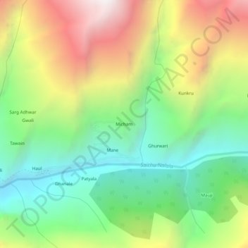
Name: Micham topographic map, elevation, terrain.
Location: Micham, Pangi, Chamba, Himachal Pradesh, India (32.97016 76.50390 33.01016 76.54390)
Average elevation: 3,141 m
Minimum elevation: 2,457 m
Maximum elevation: 4,162 m
Thank you for supporting this site ❤️
Make a donation
Make a donation
Gear up for your next adventure:
As an Amazon Associate, this site earns from qualifying purchases at no extra cost to you.