
Make a donation
Gear up for your next adventure:
As an Amazon Associate, this site earns from qualifying purchases at no extra cost to you.
Bourg-la-Reine topographic map
Click on the map to display elevation.
Make a donation
Gear up for your next adventure:
As an Amazon Associate, this site earns from qualifying purchases at no extra cost to you.
About this map
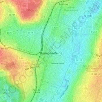
Name: Bourg-la-Reine topographic map, elevation, terrain.
Average elevation: 70 m
Minimum elevation: 43 m
Maximum elevation: 109 m
Make a donation
Gear up for your next adventure:
As an Amazon Associate, this site earns from qualifying purchases at no extra cost to you.
Other topographic maps
Click on a map to view its topography, its elevation and its terrain.
Make a donation
Gear up for your next adventure:
As an Amazon Associate, this site earns from qualifying purchases at no extra cost to you.
Parc de Billancourt
France > Ile-de-France > Hauts-de-Seine > Boulogne-Billancourt
Average elevation: 58 m
Val Saint-Olaf
France > Ile-de-France > Hauts-de-Seine > Chaville > Val Saint-Olaf
Average elevation: 128 m