Geolocate

Eaglehawk Neck topographic map

Click on the map to display elevation.

About this map

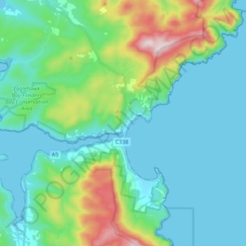
Name: Eaglehawk Neck topographic map, elevation, terrain.

Location: Eaglehawk Neck, Tasman, Tasmania, 7179, Australia (-43.05841 147.83771 -42.96276 147.98937)

Average elevation: 121 m

Minimum elevation: -1 m

Maximum elevation: 575 m

Other topographic maps

Click on a map to view its topography, its elevation and its terrain.

Tasman Island

Australia > Tasmania > Tasman

Average elevation: 19 m

Cape Pillar

Australia > Tasmania > Tasman

Average elevation: 18 m

Simmonds Hill

Australia > Tasmania > Tasman

Average elevation: 189 m

White Beach

Australia > Tasmania > Tasman > White Beach

Average elevation: 45 m

Gear up for your next adventure:

🚲MTB Frame Bag - Carry tools and maps directly on your bicycle frame
🧥Packable Rain Jacket - Breathable waterproof layer for unpredictable weather
🥾Trail Hiking Boots - Supportive boots for rough trails
🥾Waterproof Hiking Boots - Essential footwear for rugged terrain and wet Canadian trails
🏃Hydration Running Vest - Carry water and maps close to your body for speed

As an Amazon Associate, this site earns from qualifying purchases at no extra cost to you.