
Make a donation
Gear up for your next adventure:
As an Amazon Associate, this site earns from qualifying purchases at no extra cost to you.
Marquard topographic map
Click on the map to display elevation.
Make a donation
Gear up for your next adventure:
As an Amazon Associate, this site earns from qualifying purchases at no extra cost to you.
About this map
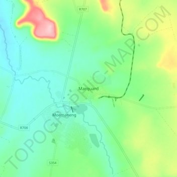
Name: Marquard topographic map, elevation, terrain.
Average elevation: 1,512 m
Minimum elevation: 1,460 m
Maximum elevation: 1,642 m
Make a donation
Gear up for your next adventure:
As an Amazon Associate, this site earns from qualifying purchases at no extra cost to you.
Other topographic maps
Click on a map to view its topography, its elevation and its terrain.
Allemanskraal Dam
South Africa > Free State > Thabo Mofutsanyana District Municipality > Setsoto Local Municipality > Aldam
Average elevation: 1,421 m
Senekal
South Africa > Free State > Thabo Mofutsanyana District Municipality > Setsoto Local Municipality
Average elevation: 1,451 m