
Mount Shasta topographic map
Click on the map to display elevation.
Mount Shasta
Mount Shasta (/ˈʃæstə/ SHASS-tə; Shasta: Waka-nunee-Tuki-wuki; Karuk: Úytaahkoo) is a potentially active stratovolcano at the southern end of the Cascade Range in Siskiyou County, California. At an elevation of 14,179 ft (4,322 m), it is the second-highest peak in the Cascades and the fifth-highest in the state. Mount Shasta has an estimated volume of 85 cubic miles (350 cubic kilometers), which makes it the most voluminous volcano in the Cascade Volcanic Arc. The mountain and surrounding area are part of the Shasta–Trinity National Forest.
About this map
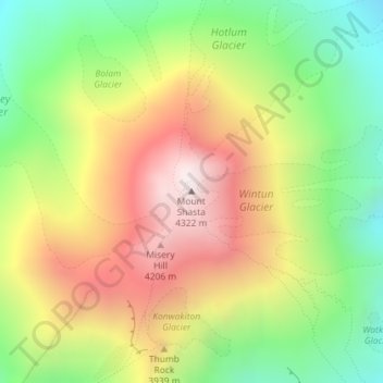
Name: Mount Shasta topographic map, elevation, terrain.
Location: Mount Shasta, Siskiyou County, California, United States (41.40915 -122.19491 41.40925 -122.19481)
Average elevation: 3,717 m
Minimum elevation: 3,194 m
Maximum elevation: 4,309 m
Other topographic maps
Click on a map to view its topography, its elevation and its terrain.
Mount Shasta City Park
United States > California > Siskiyou County > Mount Shasta
Average elevation: 1,126 m
Dunsmuir
United States > California > Siskiyou County
At an elevation of approximately 2,350 feet (720 m) above sea level, a unique setting is created by the Sacramento River in which class 3 whitewater rapids are usually created during summer run off through a town of about 2,000 residents. In plain view from some of the city's public streets, this may be one of…
Average elevation: 1,079 m
Dunsmuir
United States > California > Siskiyou County
At an elevation of approximately 2,350 feet (720 m) above sea level, a unique setting is created by the Sacramento River in which class 3 whitewater rapids are usually created during summer run off through a town of about 2,000 residents. In plain view from some of the city's public streets, this may be one of…
Average elevation: 1,075 m
McCloud
United States > California > Siskiyou County > McCloud
McCloud is located at 41°15′17″N 122°8′11″W / 41.25472°N 122.13639°W / 41.25472; -122.13639 (41.254682, -122.136321) on the southern slope of Mount Shasta, at an elevation of 3,271 feet (997 m) above sea level.
Average elevation: 1,010 m
Lava Beds National Monument
United States > California > Siskiyou County
The high elevation, semi-arid desert environment of Lava Beds National Monument receives an average of 14.22 in (36 cm) of annual precipitation, including 43.2 in (110 cm) of snowfall. The climate is characterized by warm, dry summers and cold, moderately snowy winters. The monthly daily average temperature…
Average elevation: 1,348 m
Dunsmuir
United States > California > Siskiyou County
At an elevation of approximately 2,350 feet (720 m) above sea level, a unique setting is created by the Sacramento River in which class 3 whitewater rapids are usually created during summer run off through a town of about 2,000 residents. In plain view from some of the city's public streets, this may be one of…
Average elevation: 1,077 m