
Make a donation
Gear up for your next adventure:
As an Amazon Associate, this site earns from qualifying purchases at no extra cost to you.
Vieux Chera topographic map
Click on the map to display elevation.
Make a donation
Gear up for your next adventure:
As an Amazon Associate, this site earns from qualifying purchases at no extra cost to you.
About this map
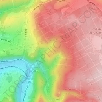
Name: Vieux Chera topographic map, elevation, terrain.
Average elevation: 305 m
Minimum elevation: 144 m
Maximum elevation: 408 m
Make a donation
Gear up for your next adventure:
As an Amazon Associate, this site earns from qualifying purchases at no extra cost to you.
Other topographic maps
Click on a map to view its topography, its elevation and its terrain.
Ninglinspo
België > Luik > Luik > Aywaille > Nonceveux > Sedoz
De Ninglinspo is de enige bergrivier van België. Zij stroomt door een gebied dat sinds 1949 beschermd gebied is. De loop van de Ninglinspo daalt van 420 meter naar 170 meter, is 3 kilometer lang en heeft hierdoor een gemiddeld verval van 8%. Ze overbrugt een hoogteverschil van 250 meter. De grootste waterval…
Average elevation: 302 m