Geolocate

Upli topographic map

Click on the map to display elevation.

About this map

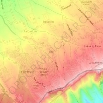
Name: Upli topographic map, elevation, terrain.

Location: Upli, Alfonso, Cavite, Calabarzon, 4123, Philippines (14.07132 120.84405 14.11132 120.88405)

Average elevation: 533 m

Minimum elevation: 344 m

Maximum elevation: 635 m

Other topographic maps

Click on a map to view its topography, its elevation and its terrain.

Amuyong

Philippines > Cavite > Alfonso

Average elevation: 543 m

Amuyong

Philippines > Cavite > Alfonso

Average elevation: 543 m

Gear up for your next adventure:

🥾All-Terrain Hiking Boots - Versatile boots for varied hiking conditions
🧥Thermal Fleece Jacket - Versatile insulation for changing mountain temperatures
🥽Outdoor Goggles - Protective eyewear for outdoor activities
🩹Moleskin Blister Pads - Direct protection for painful foot pressure points
🔋Solar Power Bank - Keep your GPS and devices charged during long outdoor trips

As an Amazon Associate, this site earns from qualifying purchases at no extra cost to you.