Geolocate

Compo topographic map

Click on the map to display elevation.

About this map

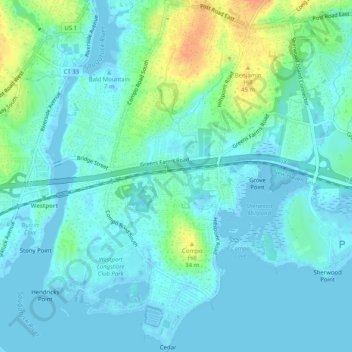
Name: Compo topographic map, elevation, terrain.

Location: Compo, Westport, Western Connecticut Planning Region, Connecticut, United States (41.10223 -73.36229 41.14045 -73.33987)

Average elevation: 10 m

Minimum elevation: -8 m

Maximum elevation: 45 m

Other topographic maps

Click on a map to view its topography, its elevation and its terrain.

Gear up for your next adventure:

💡LED Headlamp - Hands-free illumination for night hiking and camping
🧭GPS Handheld Device - Reliable GPS navigation for outdoor adventures
🥾Approach Boots - Comfortable boots for hiking and climbing approaches
🥘Camping Cookware Set - Compact nesting pots and pans for trail cooking
🔦UV Flashlight - Detect minerals or specific insects in the dark

As an Amazon Associate, this site earns from qualifying purchases at no extra cost to you.