
Make a donation
Gear up for your next adventure:
As an Amazon Associate, this site earns from qualifying purchases at no extra cost to you.
Mirante do Vértice topographic map
Click on the map to display elevation.
Make a donation
Gear up for your next adventure:
As an Amazon Associate, this site earns from qualifying purchases at no extra cost to you.
About this map
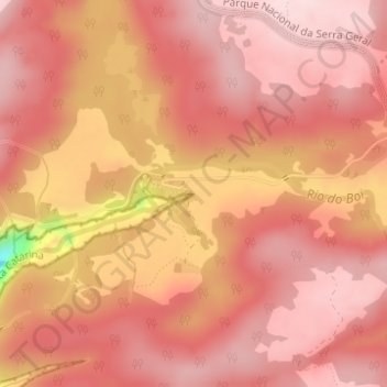
Name: Mirante do Vértice topographic map, elevation, terrain.
Average elevation: 958 m
Minimum elevation: 727 m
Maximum elevation: 1,023 m
Make a donation
Gear up for your next adventure:
As an Amazon Associate, this site earns from qualifying purchases at no extra cost to you.
Other topographic maps
Click on a map to view its topography, its elevation and its terrain.
Parque Nacional da Serra Geral
Brasil > Rio Grande do Sul > Cambará do Sul
O relevo sul catarinense é acentuado, com montanhas e vales profundos recortando a borda do planalto. O lado gaúcho é caracterizado por coxilhas suaves e vales rasos. Sem transição, as ondulações suaves dão lugar a paredões verticais e rochas basálticas. Com 950 m de altitude média, nos dias claros…
Average elevation: 475 m