Geolocate

Poonch topographic map

Click on the map to display elevation.

About this map

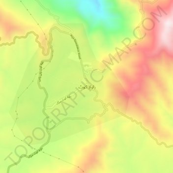
Name: Poonch topographic map, elevation, terrain.

Location: Poonch, Poonch District, Azad Kashmir, 12200, Pakistan (33.83722 73.74040 33.87722 73.78040)

Average elevation: 1,649 m

Minimum elevation: 1,294 m

Maximum elevation: 1,971 m

Other topographic maps

Click on a map to view its topography, its elevation and its terrain.

Kotli District

Pakistan > Azad Kashmir

Average elevation: 898 m

Betar Nala

Pakistan > Azad Kashmir > Haveli District

Average elevation: 1,967 m

Shounter Lake

Pakistan > Azad Kashmir > Sharda Tehsil

Average elevation: 3,357 m

Bagh Tehsil

Pakistan > Azad Kashmir

Average elevation: 1,981 m

Tehsil Dadyal

Pakistan > Azad Kashmir

Average elevation: 474 m

Muzaffarabad District

Pakistan > Azad Kashmir

Average elevation: 1,826 m

Leepa

Pakistan > Azad Kashmir

Average elevation: 2,217 m

Jagran

Pakistan > Azad Kashmir > Kundal Shahi

Average elevation: 3,283 m

Muzaffarabad

Pakistan > Azad Kashmir

Average elevation: 793 m

Mirpur District

Pakistan > Azad Kashmir

Average elevation: 511 m

Gear up for your next adventure:

💧Hydration Pack - Hands-free hydration system for long hikes
🕶️Polarized Sunglasses - Protect your eyes with durable polarized lenses
🧥Thermal Fleece Jacket - Versatile insulation for changing mountain temperatures
🧴Bear Spray Holster - Quick-access carry for essential Canadian wilderness safety
🧴Waterproofing Spray - Restore the DWR coating on jackets and tents

As an Amazon Associate, this site earns from qualifying purchases at no extra cost to you.