
Chekka topographic map
Interactive map
Click on the map to display elevation.
About this map
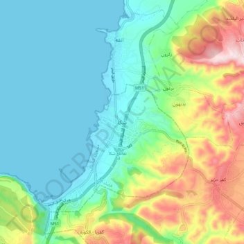
Name: Chekka topographic map, elevation, terrain.
Location: Chekka, District de Batroun, Gouvernorat du Liban Nord, Liban (34.29087 35.69508 34.37087 35.77508)
Average elevation: 121 m
Minimum elevation: -2 m
Maximum elevation: 427 m
Other topographic maps
Click on a map to view its topography, its elevation and its terrain.
Bcharre
Liban > Gouvernorat du Liban Nord
Bcharre, District de Bcharré, Gouvernorat du Liban Nord, 1377, Liban
Average elevation: 2,200 m
District du Koura
Liban > Gouvernorat du Liban Nord
District du Koura, Gouvernorat du Liban Nord, 1306, Liban
Average elevation: 284 m
Batroûn
Liban > Gouvernorat du Liban Nord
Batroûn, District de Batroun, Gouvernorat du Liban Nord, 1400, Liban
Average elevation: 31 m
Bcharré
Liban > Gouvernorat du Liban Nord
Bcharré, District de Bcharré, Gouvernorat du Liban Nord, 1377, Liban
Average elevation: 1,855 m