
可可托海镇 topographic map
Interactive map
Click on the map to display elevation.
About this map
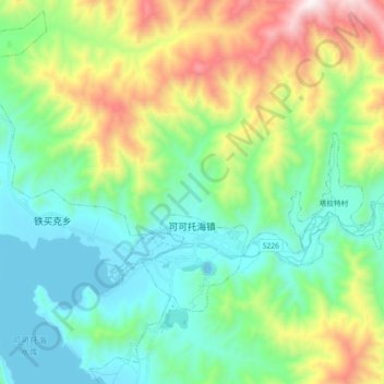
Name: 可可托海镇 topographic map, elevation, terrain.
Location: 可可托海镇, 富蕴县, 阿勒泰地区, 新疆维吾尔自治区, 中国 (47.19287 89.78476 47.27005 89.96723)
Average elevation: 1,494 m
Minimum elevation: 1,152 m
Maximum elevation: 2,358 m
Other topographic maps
Click on a map to view its topography, its elevation and its terrain.