
Tupiza topographic map
Click on the map to display elevation.
Tupiza
Tupiza is a city in Potosí Department, Bolivia. It is located at an elevation of about 2850 m. The population is 25,709 (2012 estimate). Tupiza and its environs are characterized by dramatic red escarpments which jut ruggedly skyward from the coarse, gray terrain; green agricultural land adjacent to the nearby Tupiza River provides welcome respite from the otherwise arid, thorny surroundings. The area quebradas are susceptible to flash flood runoff from sudden cloudbursts.
About this map
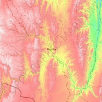
Name: Tupiza topographic map, elevation, terrain.
Location: Tupiza, Sur Chichas, Potosí, Bolivia (-21.85547 -66.33675 -21.06841 -65.24457)
Average elevation: 3,555 m
Minimum elevation: 2,266 m
Maximum elevation: 4,686 m