Geolocate

Salem topographic map

Click on the map to display elevation.

About this map

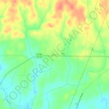
Name: Salem topographic map, elevation, terrain.

Location: Salem, Upson County, Georgia, United States (32.73314 -84.20776 32.77314 -84.16776)

Average elevation: 143 m

Minimum elevation: 115 m

Maximum elevation: 179 m

Other topographic maps

Click on a map to view its topography, its elevation and its terrain.

Thomaston

United States > Georgia > Upson County

Average elevation: 214 m

Gear up for your next adventure:

Family Camping Tent - Spacious tent suitable for family camping trips
🔭Outdoor Binoculars - Lightweight binoculars for birdwatching and hiking
🔋Lithium AA Batteries - Long-lasting power that performs in extreme cold
🧴Outdoor Sunscreen - High SPF protection for high-altitude UV exposure
Lightweight Backpacking Tent - Compact tent for efficient hiking trips

As an Amazon Associate, this site earns from qualifying purchases at no extra cost to you.