
Thank you for supporting this site ❤️
Make a donation
Make a donation
Gear up for your next adventure:
As an Amazon Associate, this site earns from qualifying purchases at no extra cost to you.
Untereggen topographic map
Click on the map to display elevation.
Thank you for supporting this site ❤️
Make a donation
Make a donation
Gear up for your next adventure:
As an Amazon Associate, this site earns from qualifying purchases at no extra cost to you.
About this map
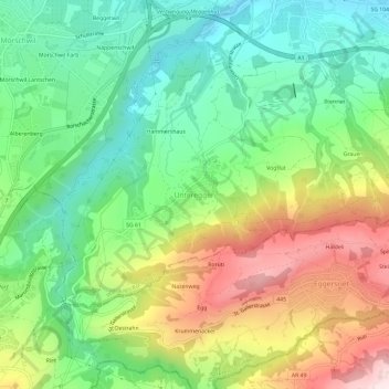
Name: Untereggen topographic map, elevation, terrain.
Location: Untereggen, Wahlkreis Rorschach, St. Gallen, 9033, Switzerland (47.43164 9.42964 47.47164 9.46964)
Average elevation: 646 m
Minimum elevation: 445 m
Maximum elevation: 971 m
Thank you for supporting this site ❤️
Make a donation
Make a donation
Gear up for your next adventure:
As an Amazon Associate, this site earns from qualifying purchases at no extra cost to you.