
Thank you for supporting this site ❤️
Make a donation
Make a donation
Gear up for your next adventure:
As an Amazon Associate, this site earns from qualifying purchases at no extra cost to you.
Lavoûte-sur-Loire topographic map
Click on the map to display elevation.
Thank you for supporting this site ❤️
Make a donation
Make a donation
Gear up for your next adventure:
As an Amazon Associate, this site earns from qualifying purchases at no extra cost to you.
Lavoûte-sur-Loire
Commune rurale de montagne située dans le Massif central, son altitude varie entre un minimum de 554 mètres et un maximum de 900 mètres, pour une altitude moyenne de 727 mètres.
Thank you for supporting this site ❤️
Make a donation
Make a donation
Gear up for your next adventure:
As an Amazon Associate, this site earns from qualifying purchases at no extra cost to you.
About this map
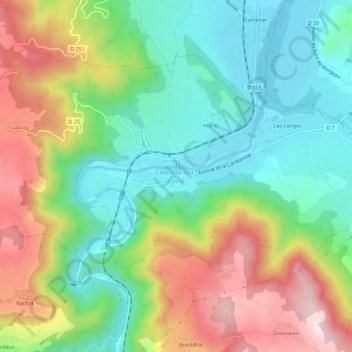
Name: Lavoûte-sur-Loire topographic map, elevation, terrain.
Average elevation: 694 m
Minimum elevation: 544 m
Maximum elevation: 936 m
Thank you for supporting this site ❤️
Make a donation
Make a donation
Gear up for your next adventure:
As an Amazon Associate, this site earns from qualifying purchases at no extra cost to you.