
Grove City topographic map
Click on the map to display elevation.
About this map
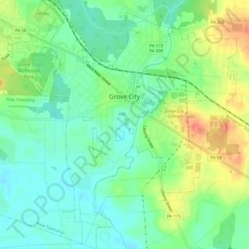
Name: Grove City topographic map, elevation, terrain.
Location: Grove City, Mercer County, Pennsylvania, United States (41.13506 -80.11591 41.17231 -80.06645)
Average elevation: 386 m
Minimum elevation: 366 m
Maximum elevation: 418 m
Other topographic maps
Click on a map to view its topography, its elevation and its terrain.
Little Shenango Dam
United States > Pennsylvania > Mercer County > Perry Township
Average elevation: 374 m
Schollard
United States > Pennsylvania > Mercer County > Springfield Township > Leesburg
Average elevation: 379 m