Geolocate

Tara topographic map

Click on the map to display elevation.

About this map

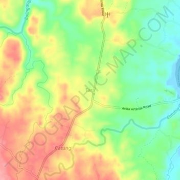
Name: Tara topographic map, elevation, terrain.

Location: Tara, Bolinao, Pangasinan, Ilocos Region, 2406, Philippines (16.27417 119.87401 16.31417 119.91401)

Average elevation: 47 m

Minimum elevation: -1 m

Maximum elevation: 97 m

Gear up for your next adventure:

💧Collapsible Water Bottle - Space-saving water bottle for outdoor activities
🥾Approach Boots - Comfortable boots for hiking and climbing approaches
🥾Trail Hiking Boots - Supportive boots for rough trails
🧼Travel Hand Sanitizer - Keep hands clean when water is scarce
💡LED Headlamp - Hands-free illumination for night hiking and camping

As an Amazon Associate, this site earns from qualifying purchases at no extra cost to you.