
Thank you for supporting this site ❤️
Make a donation
Make a donation
Gear up for your next adventure:
As an Amazon Associate, this site earns from qualifying purchases at no extra cost to you.
El Reyán/Rián topographic map
Click on the map to display elevation.
Thank you for supporting this site ❤️
Make a donation
Make a donation
Gear up for your next adventure:
As an Amazon Associate, this site earns from qualifying purchases at no extra cost to you.
About this map
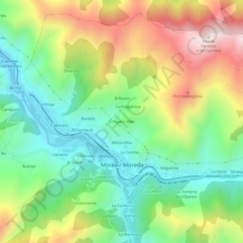
Name: El Reyán/Rián topographic map, elevation, terrain.
Location: El Reyán/Rián, Morea/Moreda, Aller, Astúrias, 33679, Espanha (43.15553 -5.75853 43.19553 -5.71853)
Average elevation: 569 m
Minimum elevation: 265 m
Maximum elevation: 1,042 m
Thank you for supporting this site ❤️
Make a donation
Make a donation
Gear up for your next adventure:
As an Amazon Associate, this site earns from qualifying purchases at no extra cost to you.