Geolocate

Williams topographic map

Click on the map to display elevation.

About this map

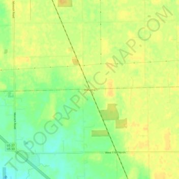
Name: Williams topographic map, elevation, terrain.

Location: Williams, Adams County, Indiana, United States (40.89894 -84.99524 40.93894 -84.95524)

Average elevation: 252 m

Minimum elevation: 235 m

Maximum elevation: 261 m

Other topographic maps

Click on a map to view its topography, its elevation and its terrain.

Monroe

United States > Indiana > Adams County

Average elevation: 251 m

Berne

United States > Indiana > Adams County

Average elevation: 260 m

Geneva

United States > Indiana > Adams County

Average elevation: 258 m

Gear up for your next adventure:

🪜Heavy Duty Carabiners - Multi-use clips for securing gear to your backpack
🛶Kayak Accessories - Essential gear for safe and fun kayaking adventures
🦟Insect Repellent - Keep mosquitoes and black flies away in wooded areas
🧣Merino Neck Gaiter - Protects against wind, sun, and cold at high altitudes
🧰Emergency Multi-Tool - Compact multi-tool for outdoor survival

As an Amazon Associate, this site earns from qualifying purchases at no extra cost to you.