Geolocate

Jersey topographic map

Click on the map to display elevation.

About this map

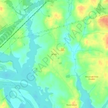
Name: Jersey topographic map, elevation, terrain.

Location: Jersey, Davidson County, North Carolina, United States (35.71097 -80.33533 35.75097 -80.29533)

Average elevation: 202 m

Minimum elevation: 186 m

Maximum elevation: 228 m

Other topographic maps

Click on a map to view its topography, its elevation and its terrain.

Denton

United States > North Carolina > Davidson County

Average elevation: 217 m

Midway

United States > North Carolina > Davidson County

Average elevation: 257 m

Denton

United States > North Carolina > Davidson County

Average elevation: 217 m

Gear up for your next adventure:

🛶Kayak Accessories - Essential gear for safe and fun kayaking adventures
💡LED Camping Lantern - Illuminate your campsite with long-lasting lanterns
🧦Hiking Liner Socks - Thin base layer to prevent friction and blisters
🧦Outdoor Socks - Durable socks designed for hiking and outdoor sports
👟Sport Hiking Sandals - Breathable footwear for water crossings and camp rest

As an Amazon Associate, this site earns from qualifying purchases at no extra cost to you.