
Make a donation
Gear up for your next adventure:
As an Amazon Associate, this site earns from qualifying purchases at no extra cost to you.
Gijzegem topographic map
Click on the map to display elevation.
Make a donation
Gear up for your next adventure:
As an Amazon Associate, this site earns from qualifying purchases at no extra cost to you.
Gijzegem
Gijzegem ligt aan de Dender. De Molenbeek-Ter Erpenbeek mondt iets ten zuiden van Gijzegem uit in de Dender. Gijzegem ligt in Zandlemig Vlaanderen en de hoogte bedraagt 2-10 meter. Langs de Dender ligt het natuurgebied Beneden-Dender, dat hier onder meer het natuurreservaat Hogedonk omvat.
Make a donation
Gear up for your next adventure:
As an Amazon Associate, this site earns from qualifying purchases at no extra cost to you.
About this map
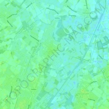
Name: Gijzegem topographic map, elevation, terrain.
Location: Gijzegem, Aalst, Oost-Vlaanderen, Vlaanderen, België (50.97156 4.01375 50.99483 4.06848)
Average elevation: 6 m
Minimum elevation: 1 m
Maximum elevation: 11 m
Make a donation
Gear up for your next adventure:
As an Amazon Associate, this site earns from qualifying purchases at no extra cost to you.
Other topographic maps
Click on a map to view its topography, its elevation and its terrain.