Geolocate

Hamby topographic map

Click on the map to display elevation.

About this map

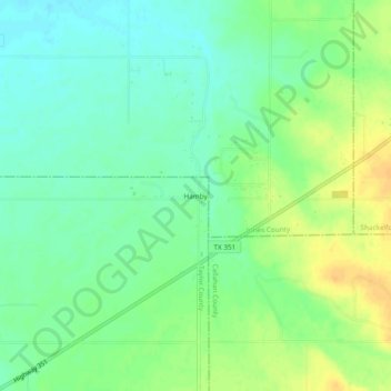
Name: Hamby topographic map, elevation, terrain.

Location: Hamby, Taylor County, Texas, United States (32.49873 -99.65120 32.53873 -99.61120)

Average elevation: 532 m

Minimum elevation: 520 m

Maximum elevation: 548 m

Gear up for your next adventure:

🥤Collapsible Travel Cup - Saves space and weight in your mess kit
🥾Lightweight Hiking Boots - Boots for comfort and mobility on long hikes
🦶Anti-Blister Balm - Prevents friction and hotspots during long ascents
🧢Beanie Hat - Keep your head warm in cold weather
🧥Ultralight Puffy Jacket - Maximum warmth that packs down to the size of an orange

As an Amazon Associate, this site earns from qualifying purchases at no extra cost to you.