Geolocate

Amba topographic map

Click on the map to display elevation.

About this map

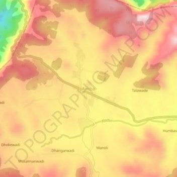
Name: Amba topographic map, elevation, terrain.

Location: Amba, Shahuwadi, Kolhapur, Maharashtra, India (16.95133 73.77797 16.99133 73.81797)

Average elevation: 619 m

Minimum elevation: 332 m

Maximum elevation: 778 m

Other topographic maps

Click on a map to view its topography, its elevation and its terrain.

Shahuwadi

India > Maharashtra > Shahuwadi

Average elevation: 601 m

Gear up for your next adventure:

🔦LED Headlamp - Hands-free lighting for early morning starts or late finishes
🔦UV Flashlight - Detect minerals or specific insects in the dark
🧥Thermal Fleece Jacket - Versatile insulation for changing mountain temperatures
👖Convertible Hiking Pants - Zip-off legs to adapt to changing weather conditions
🥾Mountain Hiking Shoes - Shoes with superior grip for mountainous terrain

As an Amazon Associate, this site earns from qualifying purchases at no extra cost to you.