
Make a donation
Gear up for your next adventure:
As an Amazon Associate, this site earns from qualifying purchases at no extra cost to you.
Brusnik topographic map
Click on the map to display elevation.
Make a donation
Gear up for your next adventure:
As an Amazon Associate, this site earns from qualifying purchases at no extra cost to you.
About this map
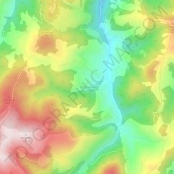
Name: Brusnik topographic map, elevation, terrain.
Average elevation: 1,202 m
Minimum elevation: 929 m
Maximum elevation: 1,523 m
Make a donation
Gear up for your next adventure:
As an Amazon Associate, this site earns from qualifying purchases at no extra cost to you.
Other topographic maps
Click on a map to view its topography, its elevation and its terrain.
Ivanjica
Serbia > Central Serbia > Moravica Administrative District > Ivanjica Municipality
Ivanjica lies in the southwest of Serbia, at the bank of the Moravica river. It is surrounded by the mountain ranges of Golija, Javor, Mučanj, Čemerno and Radočelo and is in a valley. Ivanjica's highest elevation is 1833 m, at the Jankov Kamen peak. The mountains in this area belong to the Dinaric range.…
Average elevation: 599 m