Geolocate

Towaoc topographic map

Click on the map to display elevation.

About this map

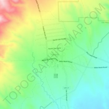
Name: Towaoc topographic map, elevation, terrain.

Location: Towaoc, Montezuma County, Colorado, United States (37.18444 -108.74954 37.22444 -108.70954)

Average elevation: 1,809 m

Minimum elevation: 1,696 m

Maximum elevation: 2,010 m

Gear up for your next adventure:

👖Convertible Hiking Pants - Zip-off legs to adapt to changing weather conditions
🥾Hiking Gaiters - Protect legs and shoes from mud, snow, and debris
🧢Sun Protection Cap - Breathable cap to protect from sun exposure
🔥Camping Stove - Portable stoves to cook outdoors with ease
🥾Hiking Shorts - Breathable shorts suitable for summer hikes

As an Amazon Associate, this site earns from qualifying purchases at no extra cost to you.