
Make a donation
Gear up for your next adventure:
As an Amazon Associate, this site earns from qualifying purchases at no extra cost to you.
Breuberg topographic map
Click on the map to display elevation.
Make a donation
Gear up for your next adventure:
As an Amazon Associate, this site earns from qualifying purchases at no extra cost to you.
About this map
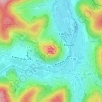
Name: Breuberg topographic map, elevation, terrain.
Average elevation: 196 m
Minimum elevation: 138 m
Maximum elevation: 324 m
Make a donation
Gear up for your next adventure:
As an Amazon Associate, this site earns from qualifying purchases at no extra cost to you.
Other topographic maps
Click on a map to view its topography, its elevation and its terrain.
Burg Breuberg
Deutschland > Hessen > Odenwaldkreis > Neustadt
Burg Breuberg steht als Höhenburg im hessischen und somit nördlichen Teil des Odenwalds auf dem 306 m hohen Breuberg, unmittelbar nördlich bzw. oberhalb von Neustadt, einem Stadtteil von Breuberg. Sie erhebt sich oberhalb der Mümling, die den steil abfallenden Bergkegel in einem weiten Linksbogen zunächst…
Average elevation: 195 m