
Akluj topographic map
Click on the map to display elevation.
Akluj
Akluj is in Malshiras tehsil and is 120 km (75 mi) away from Solapur city. It is located on the right bank of Nira River. The elevation of Akluj is 551 m (1,808 ft). The latitude 17.9000 and longitude 75.0333. The altitude in feet 1581 Lat (DMS) north 17° 53' 60 N Long (DMS) east 75° 1' 60E altitude (meters) 481.
About this map
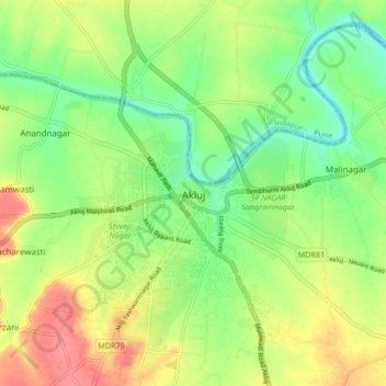
Name: Akluj topographic map, elevation, terrain.
Location: Akluj, Malshiras, Solapur District, Maharashtra, 413101, India (17.85301 74.98045 17.93301 75.06045)
Average elevation: 491 m
Minimum elevation: 461 m
Maximum elevation: 529 m
Other topographic maps
Click on a map to view its topography, its elevation and its terrain.