
Thank you for supporting this site ❤️
Make a donation
Make a donation
Gear up for your next adventure:
As an Amazon Associate, this site earns from qualifying purchases at no extra cost to you.
Les Quatre-Routes-du-Lot topographic map
Click on the map to display elevation.
Thank you for supporting this site ❤️
Make a donation
Make a donation
Gear up for your next adventure:
As an Amazon Associate, this site earns from qualifying purchases at no extra cost to you.
Les Quatre-Routes-du-Lot
Le territoire de la commune est majoritairement sans relief et d'une altitude de 125 à 130 m, excepté les coteaux du pech Maillot et Costebille à l'ouest, culminant à 202 m près du lieu-dit le Chauvet.
Thank you for supporting this site ❤️
Make a donation
Make a donation
Gear up for your next adventure:
As an Amazon Associate, this site earns from qualifying purchases at no extra cost to you.
About this map
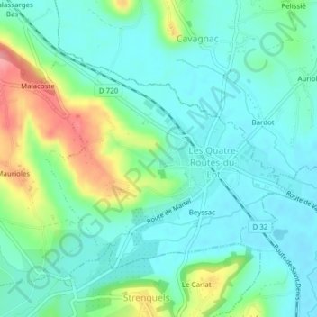
Name: Les Quatre-Routes-du-Lot topographic map, elevation, terrain.
Average elevation: 145 m
Minimum elevation: 119 m
Maximum elevation: 215 m
Thank you for supporting this site ❤️
Make a donation
Make a donation
Gear up for your next adventure:
As an Amazon Associate, this site earns from qualifying purchases at no extra cost to you.