Geolocate

Mchinga topographic map

Click on the map to display elevation.

About this map

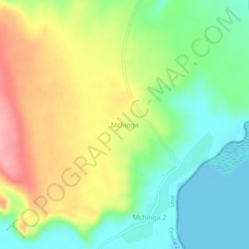
Name: Mchinga topographic map, elevation, terrain.

Location: Mchinga, Lindi, Lindi Region, Coastal Zone, Tanzania (-9.73659 39.68861 -9.69659 39.72861)

Average elevation: 52 m

Minimum elevation: -2 m

Maximum elevation: 125 m

Other topographic maps

Click on a map to view its topography, its elevation and its terrain.

Ruangwa

Tanzania > Lindi Region

Average elevation: 365 m

Kilwa

Tanzania > Lindi Region

Average elevation: 179 m

Ruangwa

Tanzania > Lindi Region

Average elevation: 365 m

Gear up for your next adventure:

🛶Canoe Life Vest - Safety vest for water sports
🧭GPS Handheld Device - Reliable GPS navigation for outdoor adventures
🍽️Titanium Camping Spork - Ultralight and indestructible eating utensil
🦶Anti-Blister Balm - Prevents friction and hotspots during long ascents
🧢Outdoor Cap - Protective cap for sun and rain during hikes

As an Amazon Associate, this site earns from qualifying purchases at no extra cost to you.