
Puthukkad topographic map
Interactive map
Click on the map to display elevation.
About this map
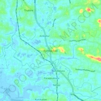
Name: Puthukkad topographic map, elevation, terrain.
Location: Puthukkad, Mukundapuram, Thrissur, Kerala, 680301, India (10.38119 76.23034 10.46119 76.31034)
Average elevation: 11 m
Minimum elevation: -3 m
Maximum elevation: 76 m
Other topographic maps
Click on a map to view its topography, its elevation and its terrain.
Irinjalakuda
India > Kerala > Mukundapuram
Irinjalakuda, Mukundapuram, Thrissur District, Kerala, 680100, India
Average elevation: 7 m
Anandapuram
India > Kerala > Mukundapuram
Anandapuram, Mukundapuram, Thrissur District, Kerala, 680305, India
Average elevation: 7 m
Vaikkara
India > Kerala > Mukundapuram > Vellangallur
Vaikkara, ambedkar colony, Vellangallur, Mukundapuram, Thrissur district, Kerala, 680662, India
Average elevation: 7 m
Kottenelloor
India > Kerala > Mukundapuram > Kottenelloor
Kottenelloor, Mukundapuram, Thrissur district, Kerala, 680672, India
Average elevation: 12 m
Amballur
India > Kerala > Mukundapuram
Amballur, Mukundapuram, Thrissur district, Kerala, India
Average elevation: 9 m