Geolocate

Winona topographic map

Click on the map to display elevation.

About this map

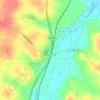
Name: Winona topographic map, elevation, terrain.

Location: Winona, Smith County, Texas, United States (32.47924 -95.19319 32.50477 -95.15967)

Average elevation: 115 m

Minimum elevation: 87 m

Maximum elevation: 146 m

Other topographic maps

Click on a map to view its topography, its elevation and its terrain.

Swan

United States > Texas > Smith County

Average elevation: 156 m

Thedford

United States > Texas > Smith County > Lindale

Average elevation: 155 m

Fun Forest Park

United States > Texas > Smith County > Tyler

Average elevation: 163 m

Owentown

United States > Texas > Smith County

Average elevation: 121 m

Whitehouse

United States > Texas > Smith County

Average elevation: 142 m

Tyler

United States > Texas > Smith County > Tyler

Average elevation: 142 m

Pine Springs

United States > Texas > Smith County > Tyler > Pine Springs

Average elevation: 155 m

Tyler

United States > Texas > Smith County

Average elevation: 147 m

Gear up for your next adventure:

💡LED Headlamp - Hands-free illumination for night hiking and camping
🔋Emergency Crank Radio - Weather alerts and power without needing batteries
🔦LED Flashlight - Powerful and long-lasting flashlight for camping and emergencies
🔋Solar Power Bank - Keep your GPS and devices charged during long outdoor trips
🧊Portable Cooler - Keep food and drinks cold during outdoor adventures

As an Amazon Associate, this site earns from qualifying purchases at no extra cost to you.