
Thank you for supporting this site ❤️
Make a donation
Make a donation
Gear up for your next adventure:
As an Amazon Associate, this site earns from qualifying purchases at no extra cost to you.
Quecho topographic map
Click on the map to display elevation.
Thank you for supporting this site ❤️
Make a donation
Make a donation
Gear up for your next adventure:
As an Amazon Associate, this site earns from qualifying purchases at no extra cost to you.
About this map
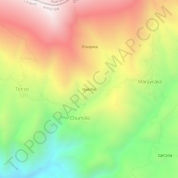
Name: Quecho topographic map, elevation, terrain.
Location: Quecho, Chumillo, Quicacha, Caravelí, Arequipa, Perú (-15.47649 -73.69750 -15.43649 -73.65750)
Average elevation: 3,447 m
Minimum elevation: 2,854 m
Maximum elevation: 4,062 m
Thank you for supporting this site ❤️
Make a donation
Make a donation
Gear up for your next adventure:
As an Amazon Associate, this site earns from qualifying purchases at no extra cost to you.