Geolocate

Saint Joe topographic map

Click on the map to display elevation.

About this map

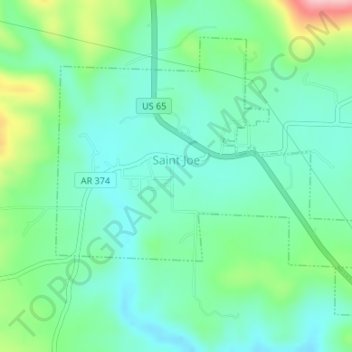
Name: Saint Joe topographic map, elevation, terrain.

Location: Saint Joe, Searcy County, Arkansas, 72675, United States (36.01782 -92.82001 36.03916 -92.78902)

Average elevation: 260 m

Minimum elevation: 217 m

Maximum elevation: 377 m

Other topographic maps

Click on a map to view its topography, its elevation and its terrain.

Harriet

United States > Arkansas > Searcy County

Average elevation: 294 m

Gear up for your next adventure:

💡Portable Camping Lamp - Rechargeable lamp for campsite lighting
🥾Mountain Hiking Shoes - Shoes with superior grip for mountainous terrain
🚲Handlebar Phone Mount - View topographic-map.com live while cycling
🔭Outdoor Binoculars - Lightweight binoculars for birdwatching and hiking
🗺️Topographic Maps - Detailed maps to explore trails, mountains, and wilderness areas

As an Amazon Associate, this site earns from qualifying purchases at no extra cost to you.