
Make a donation
Gear up for your next adventure:
As an Amazon Associate, this site earns from qualifying purchases at no extra cost to you.
Dehnsen topographic map
Click on the map to display elevation.
Make a donation
Gear up for your next adventure:
As an Amazon Associate, this site earns from qualifying purchases at no extra cost to you.
About this map
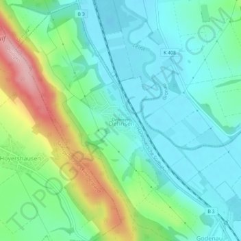
Name: Dehnsen topographic map, elevation, terrain.
Average elevation: 129 m
Minimum elevation: 78 m
Maximum elevation: 261 m
Make a donation
Gear up for your next adventure:
As an Amazon Associate, this site earns from qualifying purchases at no extra cost to you.
Other topographic maps
Click on a map to view its topography, its elevation and its terrain.
Langenholzen
Deutschland > Niedersachsen > Landkreis Hildesheim > Alfeld (Leine)
Average elevation: 206 m
Brunkensen
Deutschland > Niedersachsen > Landkreis Hildesheim > Alfeld (Leine)
Average elevation: 171 m
Make a donation
Gear up for your next adventure:
As an Amazon Associate, this site earns from qualifying purchases at no extra cost to you.
Schlehberg
Deutschland > Niedersachsen > Landkreis Hildesheim > Alfeld (Leine)
Average elevation: 127 m
Brüninghausen
Deutschland > Niedersachsen > Landkreis Hildesheim > Alfeld (Leine) > Godenau
Average elevation: 142 m
Röllinghausen
Deutschland > Niedersachsen > Landkreis Hildesheim > Alfeld (Leine)
Average elevation: 146 m
Make a donation
Gear up for your next adventure:
As an Amazon Associate, this site earns from qualifying purchases at no extra cost to you.
Föhrste
Deutschland > Niedersachsen > Landkreis Hildesheim > Alfeld (Leine) > Föhrste
Average elevation: 142 m