
Holyně topographic map
Interactive map
Click on the map to display elevation.
About this map
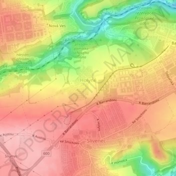
Name: Holyně topographic map, elevation, terrain.
Location: Holyně, Praag, Praha, Tsjechië (50.02080 14.32826 50.03561 14.35739)
Average elevation: 323 m
Minimum elevation: 238 m
Maximum elevation: 372 m
Other topographic maps
Click on a map to view its topography, its elevation and its terrain.