Geolocate

Wadhams topographic map

Click on the map to display elevation.

About this map

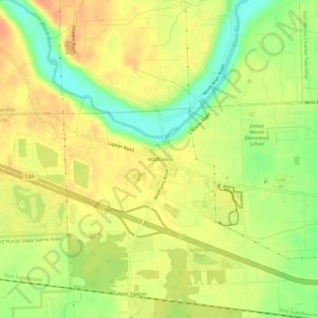
Name: Wadhams topographic map, elevation, terrain.

Location: Wadhams, Saint Clair County, Michigan, 48074, United States (42.96725 -82.55853 43.00725 -82.51853)

Average elevation: 201 m

Minimum elevation: 176 m

Maximum elevation: 216 m

Other topographic maps

Click on a map to view its topography, its elevation and its terrain.

Capac

United States > Michigan > Saint Clair County

Average elevation: 245 m

Emmett

United States > Michigan > Saint Clair County

Average elevation: 235 m

Algonac

United States > Michigan > Saint Clair County

Average elevation: 178 m

Gear up for your next adventure:

🥾Hiking Leggings - Comfortable leggings for outdoor activities
👟Leg Gaiters - Keep debris, mud, and snow out of your boots
🦯Trekking Poles - Reduced impact on joints for steep topographic climbs
🥾Hiking Boots - Sturdy boots providing ankle support and traction on rugged trails
💡LED Camping Lantern - Illuminate your campsite with long-lasting lanterns

As an Amazon Associate, this site earns from qualifying purchases at no extra cost to you.