Geolocate

Anthoor topographic map

Click on the map to display elevation.

About this map

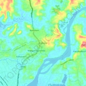
Name: Anthoor topographic map, elevation, terrain.

Location: Anthoor, Taliparamba, Kannur, Kerala, 670563, India (11.94648 75.33936 12.02648 75.41936)

Average elevation: 20 m

Minimum elevation: -2 m

Maximum elevation: 95 m

Other topographic maps

Click on a map to view its topography, its elevation and its terrain.

Payyavoor

India > Kerala > Taliparamba > Payyavoor

Average elevation: 221 m

Chengalayi

India > Kerala > Taliparamba > Chengalai > Parripayi

Average elevation: 60 m

Nediyenga

India > Kerala > Taliparamba > Sreekandapuram

Average elevation: 98 m

Valapattanam

India > Kerala > Taliparamba

Average elevation: 86 m

Peruvangur

India > Kerala > Taliparamba > Mayyil

Average elevation: 28 m

Kanakakunnu

India > Kerala > Taliparamba > Paithalmala

Average elevation: 631 m

Cheleri

India > Kerala > Taliparamba

Average elevation: 11 m

Poovanchal

India > Kerala > Taliparamba > Karthikapuram

Average elevation: 178 m

Maniyoor

India > Kerala > Taliparamba > Cheruvathala Motta

Average elevation: 35 m

Kaithapram

India > Kerala > Taliparamba > Sreekandapuram

Average elevation: 35 m

Naduvil

India > Kerala > Taliparamba > Karuvanchal

Average elevation: 288 m

Irikkur

India > Kerala > Taliparamba

Average elevation: 332 m

Therthally

India > Kerala > Taliparamba > Therthalli

Average elevation: 113 m

Gear up for your next adventure:

🔋Solar Power Bank - Keep your GPS and devices charged during long outdoor trips
🧥Insulated Jacket - Keep warm in cold outdoor conditions
🥾Trekking Poles - Adjustable trekking poles to reduce knee stress and improve stability
🥾Mountain Hiking Boots - High-traction boots for rocky terrain
🧢Hiking Sun Hat - Wide-brimmed protection for exposed mountain ridges

As an Amazon Associate, this site earns from qualifying purchases at no extra cost to you.