
Thank you for supporting this site ❤️
Make a donation
Make a donation
Gear up for your next adventure:
As an Amazon Associate, this site earns from qualifying purchases at no extra cost to you.
Pumpu topographic map
Click on the map to display elevation.
Thank you for supporting this site ❤️
Make a donation
Make a donation
Gear up for your next adventure:
As an Amazon Associate, this site earns from qualifying purchases at no extra cost to you.
About this map
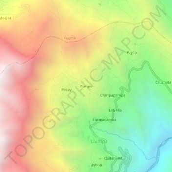
Name: Pumpu topographic map, elevation, terrain.
Location: Pumpu, Llumpa, Mariscal Luzuriaga, Áncash, Perú (-8.96800 -77.39040 -8.92800 -77.35040)
Average elevation: 3,223 m
Minimum elevation: 2,337 m
Maximum elevation: 4,144 m
Thank you for supporting this site ❤️
Make a donation
Make a donation
Gear up for your next adventure:
As an Amazon Associate, this site earns from qualifying purchases at no extra cost to you.