Geolocate

Chuyo topographic map

Click on the map to display elevation.

About this map

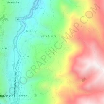
Name: Chuyo topographic map, elevation, terrain.

Location: Chuyo, San Marcos, Huari, Áncash, Perú (-9.59180 -77.18215 -9.55180 -77.14215)

Average elevation: 3,563 m

Minimum elevation: 3,005 m

Maximum elevation: 4,344 m

Other topographic maps

Click on a map to view its topography, its elevation and its terrain.

Presa de Relaves de Antamina

Perú > Áncash > San Marcos

Average elevation: 4,145 m

Gear up for your next adventure:

🧭GPS Outdoor Watch - Smart watch for navigation and fitness tracking in nature
🕯️Camping Lantern - Illuminates your entire campsite with high-efficiency LEDs
🧼Travel Hand Sanitizer - Keep hands clean when water is scarce
🧢Outdoor Cap - Protective cap for sun and rain during hikes
🥾Light Hiking Boots - Lightweight and comfortable boots for day hikes

As an Amazon Associate, this site earns from qualifying purchases at no extra cost to you.