Geolocate

Wilston topographic map

Click on the map to display elevation.

About this map

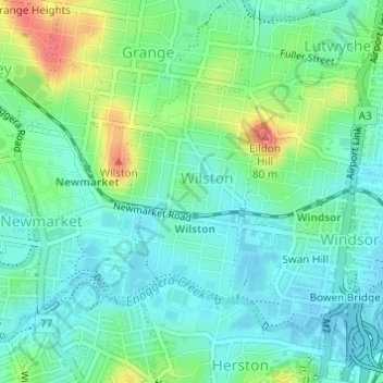
Name: Wilston topographic map, elevation, terrain.

Location: Wilston, City of Brisbane, Queensland, Australia (-27.44247 153.01129 -27.42651 153.02423)

Average elevation: 23 m

Minimum elevation: 3 m

Maximum elevation: 72 m

Other topographic maps

Click on a map to view its topography, its elevation and its terrain.

Enoggera Hill

Australia > Queensland > City of Brisbane

Average elevation: 114 m

Blunder Creek

Australia > Queensland > City of Brisbane

Average elevation: 26 m

Tangalooma

Australia > Queensland > City of Brisbane

Average elevation: 41 m

Tangalooma

Australia > Queensland > City of Brisbane

Average elevation: 41 m

Gear up for your next adventure:

💡Portable Camping Lamp - Rechargeable lamp for campsite lighting
🚲Handlebar Phone Mount - View topographic-map.com live while cycling
🐕Hiking Dog Pack - Let your canine companion carry their own water and food
Camping Coffee Maker - Brew fresh coffee anywhere on the topographic map
🚲Heavy Duty Bike Lock - Secure your bike at the trailhead or during stops

As an Amazon Associate, this site earns from qualifying purchases at no extra cost to you.