Geolocate

Manggeng topographic map

Click on the map to display elevation.

About this map

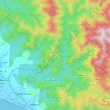
Name: Manggeng topographic map, elevation, terrain.

Location: Manggeng, Aceh Barat Daya, Aceh, 23762, Indonesia (3.59960 96.89344 3.68017 97.06451)

Average elevation: 605 m

Minimum elevation: 0 m

Maximum elevation: 2,013 m

Gear up for your next adventure:

🕯️Camping Lantern - Illuminates your entire campsite with high-efficiency LEDs
🛶Kayak Dry Bag - Waterproof storage for kayaking adventures
🛶Waterproof Dry Bags - Keep electronics and clothes dry during river crossings
📷Outdoor Action Camera - Capture high-elevation views and rugged adventures
🔥Emergency Fire Starter - Reliable ignition source for all weather conditions

As an Amazon Associate, this site earns from qualifying purchases at no extra cost to you.