Geolocate

Blakeney topographic map

Click on the map to display elevation.

About this map

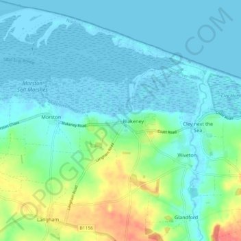
Name: Blakeney topographic map, elevation, terrain.

Location: Blakeney, North Norfolk, Norfolk, England, United Kingdom (52.92640 0.95493 52.98176 1.03163)

Average elevation: 14 m

Minimum elevation: -5 m

Maximum elevation: 62 m

Gear up for your next adventure:

🥾Light Trekking Boots - Supportive boots for multi-day treks
🧥Thermal Layer - Insulating layer for cold outdoor conditions
🧦Outdoor Socks - Durable socks designed for hiking and outdoor sports
🕶️Polarized Sunglasses - Reduces glare from snow and water at high elevations
🥾Lightweight Hiking Boots - Boots for comfort and mobility on long hikes

As an Amazon Associate, this site earns from qualifying purchases at no extra cost to you.