
The Borough District of Drogheda topographic map
Interactive map
Click on the map to display elevation.
About this map
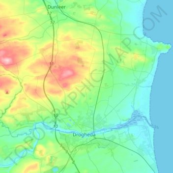
Name: The Borough District of Drogheda topographic map, elevation, terrain.
Average elevation: 50 m
Minimum elevation: -1 m
Maximum elevation: 209 m
Other topographic maps
Click on a map to view its topography, its elevation and its terrain.
Dundalk
Irlande > County Louth > Dundalk
Dundalk, The Municipal District of Dundalk, County Louth, Leinster, A91 RC44, Irlande
Average elevation: 16 m