
Marshstrand topographic map
Interactive map
Click on the map to display elevation.
About this map
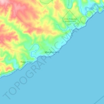
Name: Marshstrand topographic map, elevation, terrain.
Average elevation: 37 m
Minimum elevation: 0 m
Maximum elevation: 183 m
Other topographic maps
Click on a map to view its topography, its elevation and its terrain.
Chintsa
South Africa > Eastern Cape > Amathole District Municipality > Great Kei Local Municipality
Chintsa, Great Kei Ward 6, Great Kei Local Municipality, Amathole District Municipality, Eastern Cape, South Africa
Average elevation: 44 m
Komga
South Africa > Eastern Cape > Amathole District Municipality > Great Kei Local Municipality
Komga, Great Kei Local Municipality, Amathole District Municipality, Eastern Cape, South Africa
Average elevation: 603 m