Geolocate

Kathora Bk topographic map

Click on the map to display elevation.

About this map

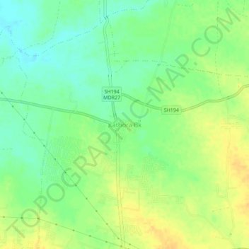
Name: Kathora Bk topographic map, elevation, terrain.

Location: Kathora Bk, Amravati, Maharashtra, 444604, India (20.97714 77.73612 21.01714 77.77612)

Average elevation: 326 m

Minimum elevation: 312 m

Maximum elevation: 340 m

Other topographic maps

Click on a map to view its topography, its elevation and its terrain.

Shahapur

India > Maharashtra > Amravati

Average elevation: 389 m

Shahapur

India > Maharashtra > Amravati

Average elevation: 389 m

Bhankheda BK

India > Maharashtra > Amravati

Average elevation: 405 m

Gangapur

India > Maharashtra > Amravati

Average elevation: 398 m

Govindpur

India > Maharashtra > Amravati

Average elevation: 424 m

Aliyabad

India > Maharashtra > Amravati

Average elevation: 371 m

Anjangaon Bari

India > Maharashtra > Amravati

Average elevation: 366 m

Aurangpur

India > Maharashtra > Amravati

Average elevation: 352 m

Gear up for your next adventure:

🦶Hiking Shoe Insoles - Added support for high arches and long days on feet
🩹Moleskin Blister Pads - Direct protection for painful foot pressure points
🧦Outdoor Socks - Durable socks designed for hiking and outdoor sports
🛁Quick-Dry Microfiber Towel - Space-saving towel that dries rapidly on the move
🛶Canoe Life Vest - Safety vest for water sports

As an Amazon Associate, this site earns from qualifying purchases at no extra cost to you.