
Make a donation
Gear up for your next adventure:
As an Amazon Associate, this site earns from qualifying purchases at no extra cost to you.
Hohe Warte topographic map
Click on the map to display elevation.
Make a donation
Gear up for your next adventure:
As an Amazon Associate, this site earns from qualifying purchases at no extra cost to you.
Hohe Warte
Die Hohe Warte (ital. Monte Coglians, friul. Colians) ist mit einer Höhe von 2780 m ü. A. der höchste Gipfel der Karnischen Alpen und liegt an der Grenze zwischen Kärnten und der italienischen Region Friaul-Julisch Venetien. Die Hohe Warte bildet mit den östlich anschließenden Gipfeln Kellerwarte, Kellerwandturm und den Kellerspitzen bis zum Kollinkofel nordseitig eine imposante, geschlossene Wandflucht, die zwischen 650 m zum Valentintörl und 1200 m zur Oberen Valentinalm abbricht.
Make a donation
Gear up for your next adventure:
As an Amazon Associate, this site earns from qualifying purchases at no extra cost to you.
About this map
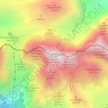
Name: Hohe Warte topographic map, elevation, terrain.
Location: Hohe Warte, Lesachtal, Bezirk Hermagor, Kärnten, Österreich (46.60727 12.88315 46.60737 12.88325)
Average elevation: 2,124 m
Minimum elevation: 1,322 m
Maximum elevation: 2,744 m
Make a donation
Gear up for your next adventure:
As an Amazon Associate, this site earns from qualifying purchases at no extra cost to you.